

Spring Summer and Fall
Experience the Unparalleled Beauty of Lake Superior's South Shore!
Spring Summer and Fall
Experience the Unparalleled Beauty of Lake Superior's South Shore!
The area abounds in celebrations of nature and the arts, and there are all sorts of ways to get out and enjoy one of the most beautiful places on earth - including many parks including Meyer’s Beach Trail, and Frog Bay and Little Sand Bay beach and museum near the cabin.
Area residents are committed to sustainability and preservation - from the farmers, orchard keepers, artists, outfitters and Hauser's Bayfield Cabin! The Bayfield and Madeline Island chambers of commerce, do an excellent job of keeping visitors up-to-date about events and businesses in the area. You can also go to the Hauser's Bayfield Cabin Facebook page to gain new insights and information.
You can subscribe to chamber email newsletters with information about events for the coming weeks and months. You may want to sign up for one or all of these newsletters via the chamber websites before your trip — you can always unsubscribe later.
Bayfield Chamber -- Madeline Island Chamber -- Washburn Chamber -- Ashland Chamber -- Cornucopia Chamber -- Herbster Chamber
Main Information Centers in Bayfield County:
Apostle Islands National Lakeshore -- Northern Great Lakes Visitor Center
Hiking
If you enjoy hiking, the Bayfield area offers a wide range of hiking trails. Here are a few links with some descriptions below….
Trail Link Bayfield Trails and Maps — Bayfield County Trails / Bayfield WI Hiking Trails / All Trails - The Top Hiking Trails in the Bayfield area (note that the trails surround the cabin) — Waterfalls and Hiking Trails in Bayfield County

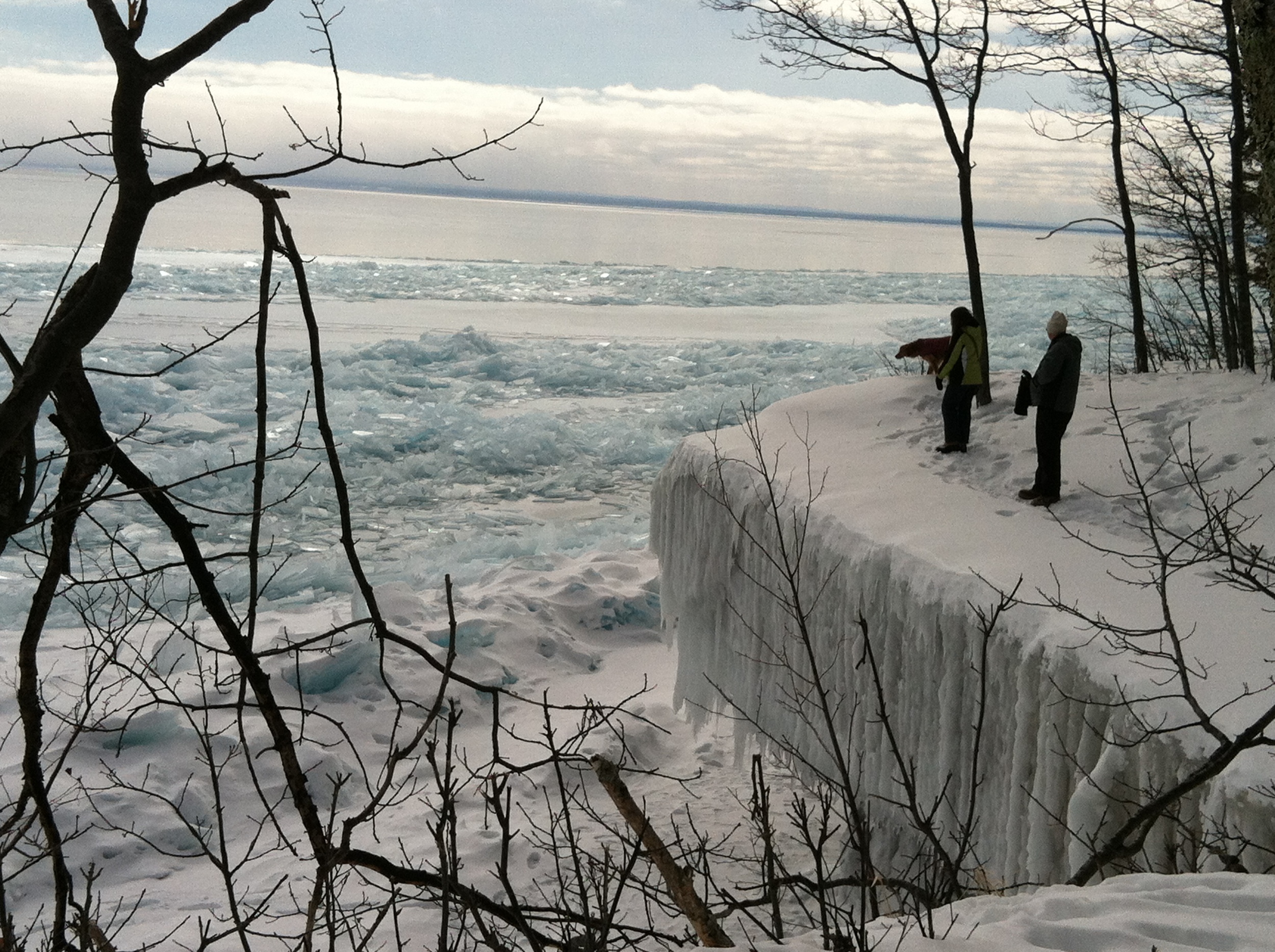
Meyers Beach Trail — Definitely a Hauser’s Bayfield Cabin favorite! Parking charge of $3 daily or $15 yearly at the kiosk on site. It is on the way to Cornucopia from the cabin. It is between the cabin and Cornucopia just off highway 13 to the right - marked by a sign. This trail requires good hiking boots and takes hikers up along the ridge over Lake Superior. The sea or ice caves can be seen from above by taking the 1.8 mile hike up the Lakeshore Trail. Although called a lakeshore trail, good views of the lake are rare until you get near the caves. Be sure to peer into “the chasm” from the bridge area and then hike beyond the promontory for rewarding views of the caves, Eagle Island, and Minnesota’s North Shore. Simply amazing in the fall and winter!
The Brownstone Trail in Bayfield: (5 miles round trip) Easy walking and biking on an old railroad bed which borders the lakeshore heading south from Bayfield. It begins near downtown Bayfield on South 3rd Street behind the DNR building (a block south of the lumber yard). This is an easy walk or bike ride splendid views of Long and Madeline Island, a former brownstone quarry railroad history markers, and old apple orchard, boats crossing the channel, and maybe even a black bear in the spring or fall! A bypass around Blue Wing Bay takes you through an old apple orchid, across a road, and back to the railroad grade. The trail continues south through ample tree cover until it emerges onto a blacktopped road. At the uphill curve, a narrow footpath leads to the end of the trail at Pike’s Bay
Big Ravine Trail in Bayfield: (2 miles round trip) Trailhead access is on 4th Street uphill to the Bayfield School. Hike uphill along the steep, hemlock-studded rim of the big ravine. Take young children by the hand! Turn left on Sweeny and park at the baseball field. The trail is behind the outfield fence to the right.
A posted trail map is displayed to plan your hike. The primary trail is a steady uphill hike along the edge of the big ravine to the orchid region of Bayfield. The path quickly enters a dense mixed forest with old growth hemlocks thriving on steep slopes of the ravine. The bypass on the overlook trail is worth the view of Lake Superior, Madeline Island and the Porcupine Mountains in the far distance. The trail ends near a farmhouse with an orchid. At this point, retrace your steps or choose from several loops shown on the signpost. Eventually, the various trails lead back to the main route and the parking lot at the school. You will see a big ravine, old growth hemlock, outcroppings with views of Lake Superior, an orchid, a quiet pond, and solitude near town. You will get an aerobic workout on this hike.
The Iron Bridge Nature Trail in Bayfield: (1/2 mile round trip) This magical winding trail is for sure-footed hikers, and follows the ravine creek under the old Iron Bridge and uphill to a rocky grotto with small waterfall. Pick up the trail at the Iron Bridge on Washington at Broad Street.
Friendly Valley Beach — Take Hwy. 13 South 10.3 miles to Friendly Valley Road. Turn left and park. Restrooms and picnic tables are available at the parking lot. Spend a day at this beautiful sandy beach bathing, walking, and picnicking. The beach is bookended by the two mouths of the Onion River. 2.5 miles total. Excellent views of Bayfield, and the islands.
Mt. Ashwabay south of Bayfield. Hike the cross country ski trails, with views across the forested valleys. The trails are easy to challenging, depending on your route. Mt. Ashwabay is located several miles south of Bayfield, at the end of Ski Hill Road. Look for the Big Top Chautauqua sign.
Jerry Jolly Trail (great for hiking and my favorite cross country ski trail in the winter) From Bayfield, take Hwy 13 South one-half mile to County J. Turn right and go 1.3 miles to the 4-way stop. Continue straight on Star Route for 2.3 miles to the Jerry Jolly/Pike’s Creek parking lot on the left-hand side of the road. Has a map with the network of trails that wind through over one thousand acres of Bayfield County Forest, the Nourse Sugarbush State Natural Area, and the Mt. Ashwabay Recreational Area. The map is oriented to the north, but you are facing south. The hike begins on the ski trail that is level until a hill going down to Pike’s Creek (this steep climb is the only way back to your vehicle). The trail then follows the creek to a steel bridge that enjoys fantastic views downstream. Just beyond the bridge on the left side is a single track hiking path that follows the other side of the creek before ascending out of the deep ravine to rejoin the ski trail. The ski trails are well posted and mowed several times throughout the summer.
Houghton Falls 1.5 miles. Drive 9 miles south of Bayfield on Hwy 13. Turn left on Houghton Falls Road and travel one-half mile east to Houghton Falls Nature Preserve parking lot. A narrow trail leads into a dense forest, and a short walk to a riverbed area call Echo Dells. Complete with falls, pools, and gravel beds, this is an excellent place to pause and explore. Further on there is a bridge crossing and several paths that lead to Houghton Point. Take the trail on the right to walk through small stands of huge old growth red pines and hemlocks. The hike ends on a rock formation that protrudes out into Lake Superior. Return via the same route.
Lost Creek Falls 1.5 miles north of Cornucopia on Hwy 13. Turn left on Klemik Road which is a gravel road. Go roughly another mile and slow down, looking to the left for a blue metal gate 30-40 yards back into the brush. Park your car on the side of the road and proceed past the gate. You will cross a bridge and the fire lane becomes the hiking path. As you begin to climb, look for a narrow fork to the right. That will take you to the base of the falls. The road takes you to the top of the falls. You can hike across large rocks to walk under the waterfall. Takes 45 minutes to 1 hour, one way.
Long Lake Trail 1.2 mile loop around Long Lake. Bayfield, drive south on Hwy 13 through Washburn and an additional 2 miles to Wannabo Road. Turn right and drive 5.6 miles to the Long Lake picnic area. Note: Parking charge of $5 daily or $20 yearly (sticker available at the National Forest Office in Washburn). This woodland trail begins at either end of the picnic area and closely follows the lake. Several benches with lake views provide a quiet place to relax. The trail is narrow in spots with a few roots and rocks, but overall, it is an easy and idyllic walk. Has picnic grounds, a sandy beach, swimming, and Long Lake views.
Valhalla Hiking Trails — 7 of them. Good for hiking for mountain biking. From Bayfield, travel south on Hwy 13 to County Road C in Washburn. Turn right and go eleven miles to the Valhalla parking lot on the left-hand side of the road. Parking charge of $5 daily or $20 yearly (stickers available at the National Forest Office in Washburn). A cross-country ski map in the parking area will give you difficulty ratings and distances for both the Valkyrie and Teutonic trails systems. These are wide and hilly trails through the Chequamegon National Forest that offer an aerobic workout.
Sioux River Flats Beach Trail (3.8 miles round trip) Walk along the Lake Superior shoreline from Bayview Park Road to the Sioux River. Access to the long, beautiful beach is five miles south of Bayfield on Highway 13.
There are also several good hiking trails on Madeline Island:
The Boardwalk Trail between Big Bay Beach and The Lagoon: This easy walk through the delicate dune landscape can be reached from either Big Bay State Park, or the Town Park.
Big Bay State Park trails wind through the woods, and around the lagoon — and you won’t want to miss the trail along the point, which is above the “minor sea caves” looking across the lake towards Michigan. This trail gives access to the “jumping off rock” loved by all summer kids on the island — it was even the site of an island wedding in 2010 — the bride and groom stripped to swimsuits after the ceremony and “took the plunge”!
Madeline Island Wilderness Preserve trails Capser Trail, an easy trail within walking distance of the ferry, and the North End Trails, which are more primitive, but offer rewarding hikes — especially in blueberry season, are part of the Preserve lands. Visit the MIWP website for more information.
Beaches
Little Sand Bay (about 2 miles from the cabin)
Meyers Beach - offers lake access. Commonly used to access the mainland sea caves in the summer and winter (if ice conditions are ok) months. From the parking area you can either spend a day lounging on the beach or hike the Lakeshore Trail for views of the sea caves from above.
Cornucopia Beach - beautiful views of the Siskiwit Bay and is within walking distance of local shops and restaurants. It’s equipped with a picnic area, playground, and artesian well.
Bay View Beach
Big Bay Beach on Madeline Island
Grant's Point Beach
Halvorson - Reiten Beach (Located at the end of Broad Street and Wilson Avenue in downtown Bayfield)
Friendly Valley Beach - Located off of Highway 13 between Bayfield and Washburn. Nice beach with views of Madeline Island and Long Island.
Harbor Park - Located in Port Wing, this sand beach offers vast views of Lake Superior and the Port Wing Harbor.
Legendary waters CASINO (Just a few miles away)
Biking
Trek & Trail --- Bayfield. Bike rentals.
Motion to Go - Madeline Island. Bike and moped rentals. Pricey! Better to bring your bike across on the ferry - even if from Trek and Trail.
Sailing

Superior Charters --- Large fleet. Bareboat or captained. Learn to sail. Over 60 boats 26'-46'.
Northern Breezes Sailing School --- Vacation Courses are held in the beautiful Apostle Islands near Bayfield, Wisconsin.

Cruises
For those of you with a dog or dogs at the cabin - Willigan’s Adventures offers custom trips to the islands out of Roy’s Point Marina (between Bayfield and Red Cliff on the right) and you can take your dog with you! You can reach them at 763-381-7076.
Kayaking / stand up paddle boarding (SUP) / Boat Rentals

Trek and Trail. Guided Sea Kayak Tours, Rentals, Shuttles, Instruction Courses. In Bayfield next to the Madeline Island Ferry terminal.
The Northwest Passage. Sea Kayaking and Camping Trips in the Apostle Islands.
Lost Creek Adventures Cornucopia. Kayak trips. Stand Up Paddle Boarding rental, Instruction, guided trips, wilderness classes.
Madeline Island also has outfitters offering kayak trips and rentals for the State Park cliffs and Big Bay lagoon. See Madeline Island Chamber for outfitter information.
Marinas
Pike's Bay Marina Bayfield
Port Superior Marina Bayfield
Madeline Island Marina Madeline Island
Siskiwit Bay Marina Cornucopia
Fishing
Valid State of Wisconsin fishing license is required. Click here for information on obtaining a license either by phone or locally.

If you have a boat, the fishing off of Bayfield in Lake Superior near Long Island or the southern tip of Bass Island is usually pretty good — fish for Lake Trout, Whitefish, etc. Fishing off the ore dock pier in Washburn can be good at times. Bridges and piers are good for springtime casting, while trolling proves successful during the summer months.
Dave’s Fishing Charters On the Nauti Gal. Capt. Dave smokes, but if you don't mind an occasional whiff, he does a great job, and has been doing it for 30 years.

The best place to fish with public access near Bayfield is on the lakes in the Chequamegon National Forest. Just past Washburn on Hwy 13 is a bait shop on the right. The folks at the bait shop can tell you what lure or bait to use and where to fish, depending on the time of year you are here. Just past the bait shop is Wannebo Road. If you take a right on Wannebo and go about 6 miles, you'll see a sign for Long Lake on the right. There is a hiking trail around the lake and there are some fish in the lake. Just down the road from Long Lake, on the same road you took a right on to get to Long Lake, about 4.5 miles on, is Birch Grove Lake which is probably a better fishing lake. Of course, there are other lakes in the forest as well. Diamond Lake and Lake Namekagon south of Highway 2 off Highway 63 offer the best variety of fish.
Want to take a road trip? You can drive down to the Hayward area to fish.
The Brule river is another great place to fish. It is the finest spring-fed trout stream in the Upper Midwest.
Museums
Madeline Island Historical Museum Learn about the rich history of the area. Did you know this was one of the main centers of the fur trade starting in the late 1600’s, under France, then England, then the United States? Or did you know that Madeline Island is sacred to the Ojibwe?
Hokenson Brothers Fishery Museum is located at Little Sand Bay - near the cabin. The cabin was formerly owned by the Hokensons.
Bayfield Heritage Association BHA maintains a collection of artifacts and archival materials relating to the history of Bayfield and the surrounding region. The collection focuses on the general themes of settlement, agriculture, logging & lumbering, transportation and tourism. Archival materials include maps, early city records, photographs, newspapers, brochures, business records and personal papers. Located at 30 N. Broad Street.
Bayfield Maritime Museum Visitors can expect to find displays and activities centered around boat building traditions, sailor crafts and more. Located at 131 S. First Street.
Wineries
Bayfield Winery Ltd Located at Hauser's Superior View Farm.
White Winter Winery in Iron River.
Shopping
Shops at Cornucopia
Ehler’s Store Cornucopia.
Howl - Rittenhouse & First, Bayfield.
Brownstone (yarn shop upstairs) and Sweet Sailing, Rittenhouse, Bayfield.
Joanne's Scandinavian, Rittenhouse & Broad, Bayfield.
Bates Art Bar, Broad Street, Bayfield.
Apostle Islands Booksellers, Rittenhouse, Bayfield.
What Goes 'Round/Bayfield Books, Second Street, Bayfield.
Stone's Throw, Second Street, Bayfield.
Orchard's Edge Quilt Shop, Rittenhouse & Broad, Bayfield. Sewing supplies.
Eckels Pottery, Hwy 13 just south of Bayfield.
Karlyn’s Gallery - Hwy 13, Washburn. Art supplies & classes.
Bell Street Gallery on Madeline Island.
Winter
Not Just For Snuggling!
Winter
Not Just For Snuggling!
Winter Activities
The Scenery
There are so many spectacular spots it’s hard to single any out! The region’s beautiful mixture of rolling hills, rocky crags, and tall pines offer some truly scenic hikes, giving nature enthusiasts the opportunity to enjoy the winter wonderland at its finest. Take a drive along Highway 13 for breathtaking views of Lake Superior ice formations, or out any country road to snowy farm fields and forests. Stop for the views that beckon — don’t forget your YakTracs, snowshoes or cross-country skis. Photo-ops abound! The “Blue Ice” photo at the beginning of this section was taken on Big Bay State Park point trail the same year the Ice Caves created their sensation. Madeline Island Trails. nnn
Dog-Sledding

A great area dog sled guide is Wolfsong Adventures. They have dog sled day trips and weekend adventures, where you can learn to drive a team of Siberian Husky sled dogs. They have been in business in the Bayfield area since 1997.
Northern Pines Dogsled Race in Iron River is on February 7 (same day as Land O Lakes 3 Bear Dogsled Race)
Skiing, Snowboarding and Snowshoeing
Bayfield’s rugged and beautiful wilderness provides some of the most scenic ski and snowshoeing trails in the country — for all ages and levels.

Mt. Ashwabay Alpine and Cross Country Trails Just south of Bayfield at the end of Ski Hill Road. Home to stunning trails perfect for alpine and cross country skiing, as well as snowboarding and showshoeing. Mt Ashwaybay hosts several winter activities and events. Mt Ashwabay offers 12 runs, and 35 km of groomed cross country ski trails, and a tubing and terrain park called Little Willie. Alpine skiers can enjoy more than 65 acres of chairlift-operated slopes, while beginners can develop their skills in their own exclusive area. Mt. Ashwabay also offers a competitive season for avid winter athletes, with NASTAR Races each Sunday giving skiers and snowboarders from across the country the opportunity to race — open to all levels. Mt. Ashwabay’s picturesque cross country ski area features some excellent routes for both classic and skate-style skiers, covering more than 40 kilometers. Also perfect for snowshoers, the trails are regularly maintained and monitored to keep them in prime condition for the whole season. Beginners can embark on the smooth Sugar Bush Trail, while intermediate skiers have the expanse of the Anchor, Seagull and Raven Trails. Advanced skiers can combine the Sugar Bush, Deer Path and Raven Trails to reach Mt. Ashwabay’s chalet. Mt Ashwabay also has some excellent runs for snowboarders.
There are more than 100 miles of snowshoeing and 130 miles of cross country skiing, including the Brownstone Snowshoeing Trail, Big Ravine Snowshoeing Trail, and Mt. Valhalla Cross Country Ski Trail. Many local businesses offer tours and events for cross country skiers and snowshoers.
Snowmobiling
The Bayfield area, benefits from lake effect snow, so snowmobile riders can have an extended snowmobile season. We are close to many inland Bayfield County Snowmobile Trails. There is plenty of room at the cabin to keep your snowmobile and snowmobile trailer in the driveway!
Bayfield County snowmobile trails are well marked and maintained by the Bayfield County Snowmobile Alliance using a high tech Sno-Plane groomer — reportedly the only one in Wisconsin. There are 600 miles of uncrowded trails throughout Bayfield County. Some of the trails are in non-developed national and state forests and parks. The peace and solitude gives you an unsurpassed experience. The interconnecting trail system allows you to travel to a number of restaurants in the area. You can call 800-472-6338 for current trail conditions or to receive a hard copy of a snowmobile map. Do you need to renew your Wisconsin snowmobile permit? Visit the Wisconsin DNR web page for snowmobile licenses and information.
Ice Caves
The Ice Caves became a world-wide phenomenon in 2014, after social media picked up on the opening after five years of no access due to warm winters. Tens of thousands of people from all over the world came to see the Ice Caves for themselves. The nearly two mile trail to the caves from the Meyer’s Beach access point near Cornucopia is actually over the lake — over the ice that forms during the winter season. Not all years are the same — sometimes the ice doesn’t get thick enough, sometimes it is extremely slick as in 2015, sometimes the trail is only open for a few days, sometimes the trail never opens during a season. But when conditions are right, the Ice Caves are truly a sight to see! Apostle Islands National Lakeshore reports on conditions; so be sure to check to see if they are open!
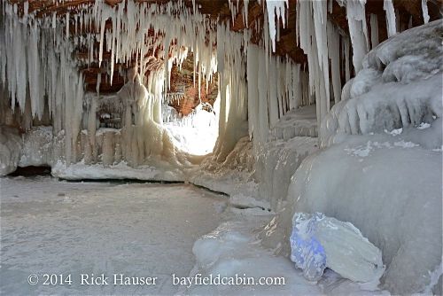
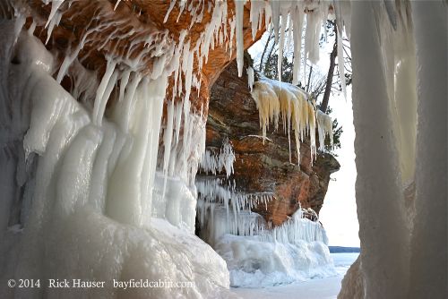
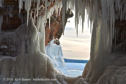

Here are a few photos I took at the ice caves in 2014. I arrived at the Meyer's Beach area about 1 PM on Monday February 3, 2014. The lot was full, so I parked about 20 cars down the road from the main lot and made the half hour hike to the ice cave area, getting there about 2 PM. I took pictures up until sunset at 5 PM. The best time to visit the ice caves is during the week, as parking is easier, and there aren't so many people in the way of "just a landscape shot."
Hauser's Bayfield Cabin is just 8 miles from the Meyers Beach access point!
Book Across The Bay in February

A cross-country skiing race across the frozen bay between Ashland and Washburn. The race takes place at night; the trail is lit by luminaries, and there are warming stations and entertainment along the course. You don’t have to race! You can ski, snowshoe or walk the course just for fun, too. Music and food at the end of the race in Washburn.
Bayfield Winter Fest in early March

Celebrating Snow, Ice and Cabin Fever! Take the PolarPlunge, do the WinterDash or the Run On Water! Or just have fun watching others…
THE FERRY, WINDSLED OR ICE ROAD TO MADELINE ISLAND
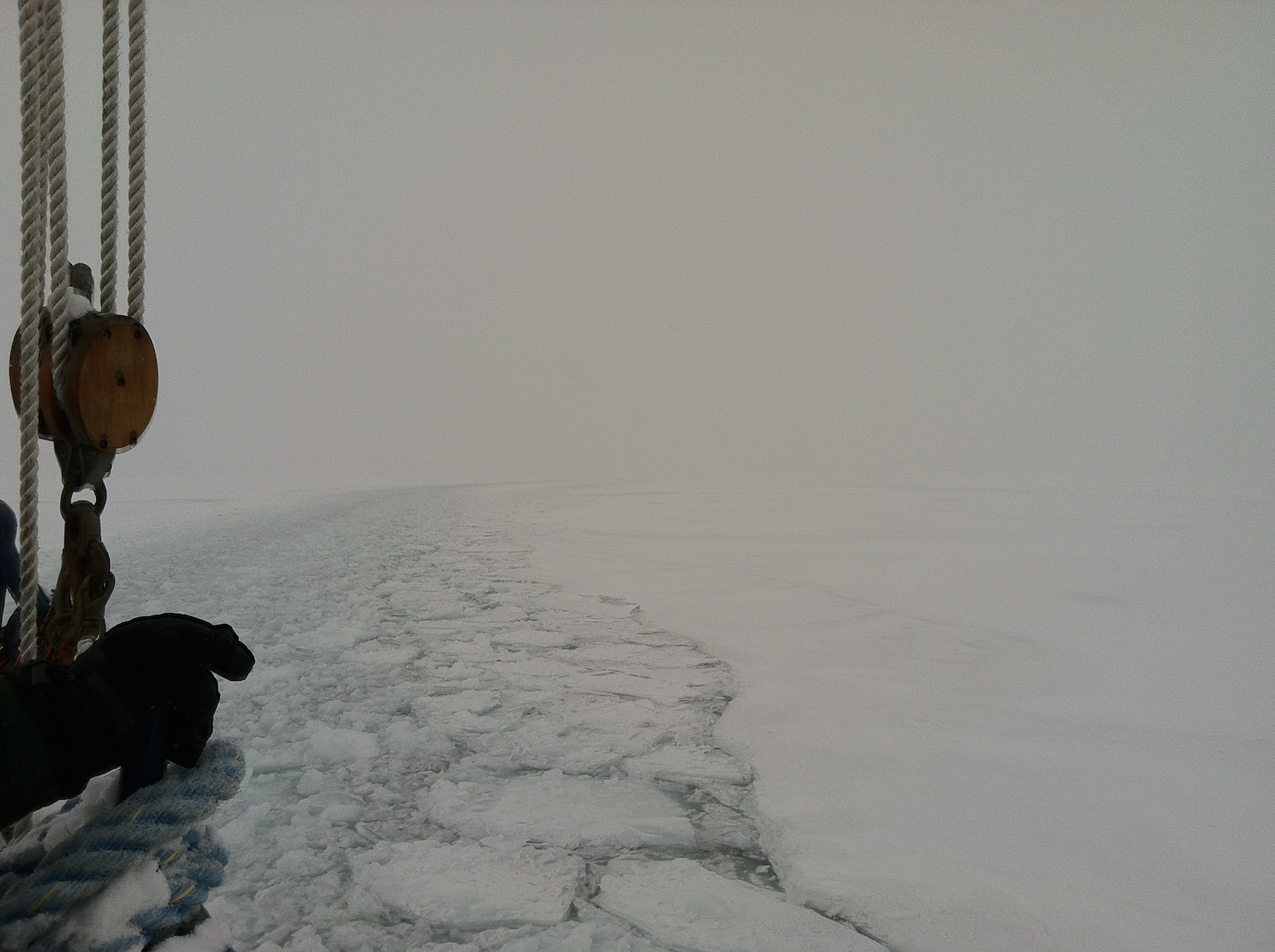
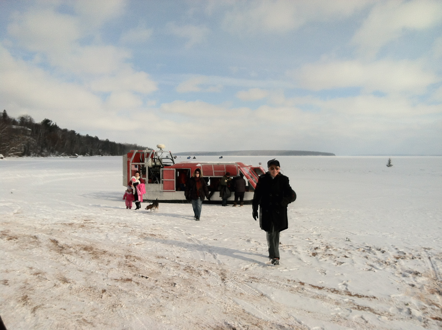
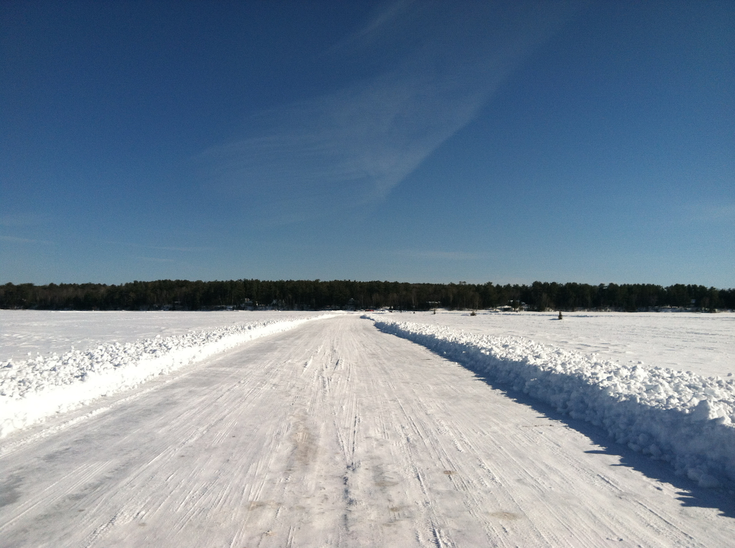
Just before the bay freezes, the ferry travels through a “river of ice”. The Windsled (bring your earplugs!) runs for two to three weeks after the ferry stops and before it starts again, “either side of the Ice Road”. If the islanders are lucky, the bay freezes thick enough for the ice road to open, and they are no longer subject to a schedule to travel to and from the island! Sometimes the road is open for visitors to drive to the island, too. If you drive the Ice Road, please observe the 15 mph speed limit — this limit is not to keep you from sliding on the ice — it is to prevent the ice from oscillating, creating cracks that damage the road and shut it down for everyone!
Check the Madeline Island Chamber website for schedule information for the Windsled and the Ice Road.
At the End of the Day
Returning home to a warm, cozy fire at Hauser’s Bayfield Cabin to wrap up the day is the best part. Winter isn’t the season to hibernate — with so much to see and do in Bayfield, your great outdoor adventure can be as exciting or as relaxing as you want it to be!
Point to LaPoint Swim
Point to LaPoint Swim
The 18th annual Point to La Pointe open water swim set for Saturday, August 3 2024, sold out in three months and with good reason.
“There’s nothing else like this,” said Race Director, Ursula Garrison. “This is the only open water swim on Lake Superior.”
The Point to La Pointe swim is a fundraiser for the Bayfield Rec. Center. For the first time in race history, organizers created a waiting list due its popularity. Annually, about 600 swimmers will make the 2.1 mile journey from Bayfield to La Pointe on Madeline Island. One of the unique aspects of this race is that there are no road connections between the start and finish lines. Participants swim one way, and the Madeline Island Ferry Line provides complimentary rides back to the mainland.
Among this year’s swimmers will be the “WisconSWIM Mermaids.” The group of four women from Northwest Wisconsin are using the Point to La Pointe to train for a swim across the English Channel in mid-August. They are set on becoming the first female relay team from Wisconsin to swim the English Channel.